Tuesday, October 15, 2019

2019: Chesapeake Bay

13 October 2019
Depart: Summit North Marina, Bear, DE 8:50
Arrive: West River Anchorage #1 4:00
Distance: 63 nm

After walking it a couple of times, I decided to look at the app on my phone that measures the distance I walk. To the closest restroom from the boat was .33 miles (each way). The one we walked to last night for our showers was further away than that. I got my morning exercise by walking to the toilets and back before we continued on our journey.

We traveled the remainder of the C&D Canal this morning. As we passed by, we checked out the Chesapeake City free dock. Because of the spacing of the boats there, it appeared to be quite full. We thought all the boats would have left first thing in the morning.


Free Dock at Chesapeake City, DE

On the opposite side of the canal, we saw twin boats docked near Schaefer's Canal House Marina.


Schaefer's Canal House on the C&D Canal

Our trip today included a couple of interesting barge sightings - both with drogues.


A barge carrying barges!

A barge carrying a classic wooden boat. A Trumpy?

Drogue is visible in the water behind this barge.

We dodged a lot of debris in the water again today. With the size of the objects, a hit could cause considerable damage!


Tree / limb at least 6 feet long!

When we could take our eyes off the obstacles in the water, we enjoyed the view of the bridges and lighthouses.


Baltimore Light on Chesapeake Bay

William P. Lane Memorial Bridge

Thomas Point Shoal Lighthouse 

14 October 2019
Depart: West River Anchorage just south of Annapolis, MD 8:00
Arrive: Mill Creek Anchorage off the Wicomico River in VA 4:50
Distance: 76 nm

We planned an early departure, but when Clark got up and took a look, he found a very foggy sky. He let me stay in bed an extra few minutes before we got up and got going.


"Home Too" in the foggy West River anchorage.

Morning mist in Maryland

As we did yesterday, we again dodged tree limbs and pilings in the water. If not for the debris in the water, it would have been a rather boring ride. The debris fields kept us on our toes!


Another tree-sized piece of wood floating on the waterway
due to severe flooding in the area.

As the sun lowered in the sky, Clark captured a silhouette of a passing ship.


We decided to anchor in Mill Creek as we have been here before and liked it. The one drawback it has is the lack of services - weak cellphone and no digital television. As we approached the anchorage, "Sunset Delight" turned off to port and "Home Too" continued on to our starboard side. They needed to refuel before tomorrow's travels.

As we dropped our anchor for the night, it made sounds like a squeaky wheel. I found it unpleasant to listen to, and Clark found it disturbing from a wear-and-tear point of view. While we waited for Franklin and Cathy to come into the anchorage to join us, Clark and I disassembled the windlass to lubricate the parts in an attempt to eliminate the noise.

We have taken apart the windlass a few times now. It takes two. One to pull the pieces off and the other to read the step-by-step instructions and make sure nothing blows or rolls off the deck. Clark had a devil of a time finding the squeaky culprit until suddenly he had an ah-ha moment and realized it was the infamous "stripper" that was causing the noise. Once he applied liberal lubricant to that part, the noise disappeared completely.

Clark had the last piece to be complete the reassembly in his hands as "Home Too" entered the anchorage. By the time they finished fueling and found the anchorage, the sun had set.


Sunset at Mill Creek, VA

As they started to anchor the anchor roller broke. Consequently, they rafted with us. Fortunately the next few nights for them are in a marina, so they will have a chance to fix the roller before needing to anchor again.


15 October 2019
Depart: Mill Creek Anchorage 9:05
Arrive: Hampton, VA Anchorage 4:15
Distance: 53 nm

The trip from Wicomico River to Hampton felt like it took forever. Although we had not even a ripple in the anchorage, as soon as we got out in the open, we found 15 knot winds and rocky seas. On the bright side, we did not find any debris on today's travels. Despite watching intently, we did not see any traps on the water either - even in the fish trap zone.

Starting early afternoon, we repeatedly heard a Coast Guard Securite announcement concerning a super tanker due to arrive at Thimble Shoal Channel at 2:00. As we also approached Thimble Shoal Channel, we kept a watch out for the vessel named "Cosco Jasmine". Finally, around 3:00 we saw the ship on the horizon. AIS revealed that we our paths would cross in approximately 30 minutes.


1200 foot long super tanker heading for Norfolk, VA

This sailboat looks very small beside the cargo ship.

Getting up close and personal with the cargo ship was the excitement for the day. As the ship turned towards Norfolk, we turned to Hampton, Virginia for the night. Entering the Hampton River, we saw familiar sights including Hampton University.


Old Point Comfort Lighthouse

Hampton University

Great boat name ... "Dessert First"

Franklin dropped off at the Hampton Public Piers for the night while we continued on under the nearby bridge to anchor in a spot we have used a few times.


Our anchorage for the night in Hampton, VA

As I worked on the blog update and Clark did some repair work on a propane leak, we heard someone shouting at us. It turns out some sculling boats were passing by. The person who yelled told Clark that his parents were from New Jersey. He had obviously seen "Rumson, NJ" as our home port shown on the hull of our boat.


Clark wants to attend a Snowbird Boaters' Rendezvous here in Hampton starting Thursday and lasting until Sunday. There will be seminars and opportunities to meet more boaters. Clark is particularly interested to hear Chris Parker speak. Chris Parker's weather broadcasts provided us with the critical information we needed to be able to travel safely on "Sea Moss" in the Bahamas in 2016.


Monday, October 14, 2019

2019: Delaware Bay

12 October 2019
Depart: Cape May, Utsch's Marina, 9:50
Arrive: Summit North Marina, Bear, DE 6:15
Distance: 59 nm

Given earlier predictions on wave heights in Delaware Bay, we expected to be held captive in Cape May until Sunday. However, Clark reviewed the wave heights early this morning and decided that we could "make a break for it" if "Home Too" was amenable. Franklin and Cathy voted "Aye", and we threw ourselves into high gear to make our escape as quickly as possible. As it was a last-minute decision to move, it took some time to prepare to depart. We managed to leave just before 10:00.

Clark said it would be a slow ride up the Delaware River, and he was not joking. The further along we got, the worse the numbers. We saw our speed continuously drop 8.8 became 7.7 became 6.6 and eventually barely 6.0 knots. You know it is a slow day on the water when you celebrate to be going 6.8 knots. When we got over 7 knots we were cheering!

As we traveled north on the Delaware River bucking the current, all sorts of debris (tree branches and lumber) came our direction as it floated out with the tide. We saw huge planks floating by including some with long nails protruding from the boards! The area has experienced heavy flooding due to a storm out in the ocean.

We hoped to stay tonight at Delaware City where we have stayed in the past. However, when we talked to them, they directed us to call the Summit North marina. Delaware City Marina closed at 5:00 p.m., and we would not arrive until closer to 6:00. Given their "tricky" dock setup, they do not want anyone tying up without them on hand to assist. We contacted Summit North, and they said they would accommodate us.

Another possibility for a place to stay for the night was the Chesapeake City free dock. Clark contacted our friend Kenny on "Daybreak" to ask if the city had a camera on the dock so we could see if there would be room for us. Kenny did one better ... he drove by in his car and checked it out for us. The docks were full, so no go there.

We were well pleased with the day's travel in that we never saw anything close to the 3-5 foot waves that were predicted. We had calm waters for the entire trip and very little boat traffic. Even the commercial traffic seemed to be staying off the river. Even so, by the time we reached Summit North Marina, we were all ready to call it a day.

Views on today's travels included ...


Clark saw a railroad bridge up ahead, so

he tried for the "down-the-tracks" picture.

Due to a full moon and flooding from tropical depression Melissa, "Sunset Delight" rode high enough in the water to allow Clark to try for a "down the tracks" picture. Normally, the tracks would be so high he would not be able to look down them for a picture.

We passed four small lighthouses in Delaware Bay ... Cross Ledge, Miah Maull Shoal, Brandy Wine, and Ship John Shoal Lighthouse.

Cross Ledge Lighthouse

Ship John Shoal Lighthouse

Salem Nuclear power plant was on our starboard side as we traveled the Delaware River.


Salem Nuclear Power Plant in NJ

We arrived at Summit North Marina in time to get some great twilight and sunset pictures.


Late-day arrival at the C&D Canal

Sunset at the Summit North Marina docks

Night sky in Bear, Delaware


2019: Cape May NJ

October 8, 9, 10, and 11, 2019
Utsch's Marina, Cape May, NJ
No boat travel.

We spent over 4 days in Cape May waiting for the waves to settle in Delaware Bay to a level that would permit us a comfortable transit to the C&D canal and eventually Chesapeake Bay.
While we waited for any opportunity to move on,  Clark worked with Franklin on "Home Too" to improve their on-board equipment to enhance their docking and anchoring capabilities. 

For better protection from damage caused by rubbing on pilings at marinas, Clark helped Franklin make fender boards. The folks at Utsch's marina found 2 2x4s that could be re-purposed into fender boards.  Clark drilled the holes, and Franklin did the assembly. Evelyn mostly watched!


Team Project - Nearly finished fender boards

Franklin applying the finishing touches 

The much larger and time-consuming project entailed swapping out their existing anchor, chain, and rode with a more robust setup. After many hours of measuring, analysis, and discussion, a decision was finally reached on how much line, how much chain, and what type and size anchor to install to replace the existing setup.  They decided on a spade design. Due to the somewhat compact size of the anchor pulpit, much deliberation was put into deciding which  brand and weight of anchor to use for the job to allow it to fit in the available space and hold the boat even in windy conditions.

Although we spent the majority of our time at the marina, we did manage to walk into town twice.  Since it is October, we got to see some seasonal flowers and Halloween decorations. We also visited both locations of a local marine store,  Marine Gear. Franklin bought the anchor project materials there. While there, I found some very inexpensive boat shoes to pick up for Clark and for myself.

Sights we saw around Cape May during our stay and on our walks included ...

Seasonal Pumpkin Patch

Halloween Horse and Ghost

Deserted Downtown Cape May, NJ


Froggy Bicyclist -- at local gas station


Monday, October 7, 2019

2019: Rough travels Sandy Hook to Atlantic City

5 October 2019
Depart:  Rumson NJ 12:00
Arrive: Brielle Yacht Club 4:45

Looking at the upcoming marine forecast, Clark decided that our best option for travel would be to leave as quickly as possible. We made our decision around 4 o'clock Friday afternoon and put ourselves instantly into travel- prep mode.  Other than sleeping through the night, we worked non-stop getting ready to drop our lines and get underway.  Provisioning the boat and shutting down the house are time- consuming activities.   We targeted an 11 o'clock departure and managed to leave by noon.  For this trip, we have a buddy boat, so we headed to Atlantic Highlands to meet up with our travel partners - Franklin and Cathy on "Home Too".


"Home Too" near Atlantic Highlands, NJ

As we approached Manasquan Inlet, Clark checked times and distances and decided we had to make a stop here for the night. Brielle Yacht Club quoted $3 per foot,  Hoffman's quoted $4, so we opted for BYC. A young teenager came to the dock to help us tie up for the night. Before we could get settled, someone from Hoffman's marina came out and told us to "get off their dock". Huh?
After several phone calls, we found out that there is a new owner of BYC, and the prior owner did not make it clear to the new owner that this particular section of dock where they told us to tie up is leased to Hoffman's. After much scurrying around by the young dockhand, he managed to find us two new slip assignments.

I thought after the embarrassing "land dispute" fiasco that we might get offered a discount for our troubles. Instead, when Clark went to check in, they told him the rate was misquoted because it had just gone up to $4 per foot. So, I guess, in a way, we got a discount because Clark convinced them to give us the quoted rate.

But wait ... the fun wasn't over yet! Apparently, several slips have not been used since Superstorm Sandy. After Clark and I got settled in,  the woman on a neighboring boat said,  "You better leave at 6:00 in the morning or you won't get out of that slip until noon! " She wasn't joking!
We docked at mid-tide on a 4-foot tide change and saw we had .9 feet of water under the boat.  

Two hours later, the boat was sitting on the bottom! On the bright side, the slip was so narrow compared to the width of our boat, we couldn't tip over. The boat rested tight on a pole on one side and only allowed room for a somewhat squished fender on the other to keep us off the finger dock.

Pictures taken approaching or at Brielle Yacht Club ...

At the railroad bridge, Manasquan Inlet

Sunset at Brielle Yacht Club

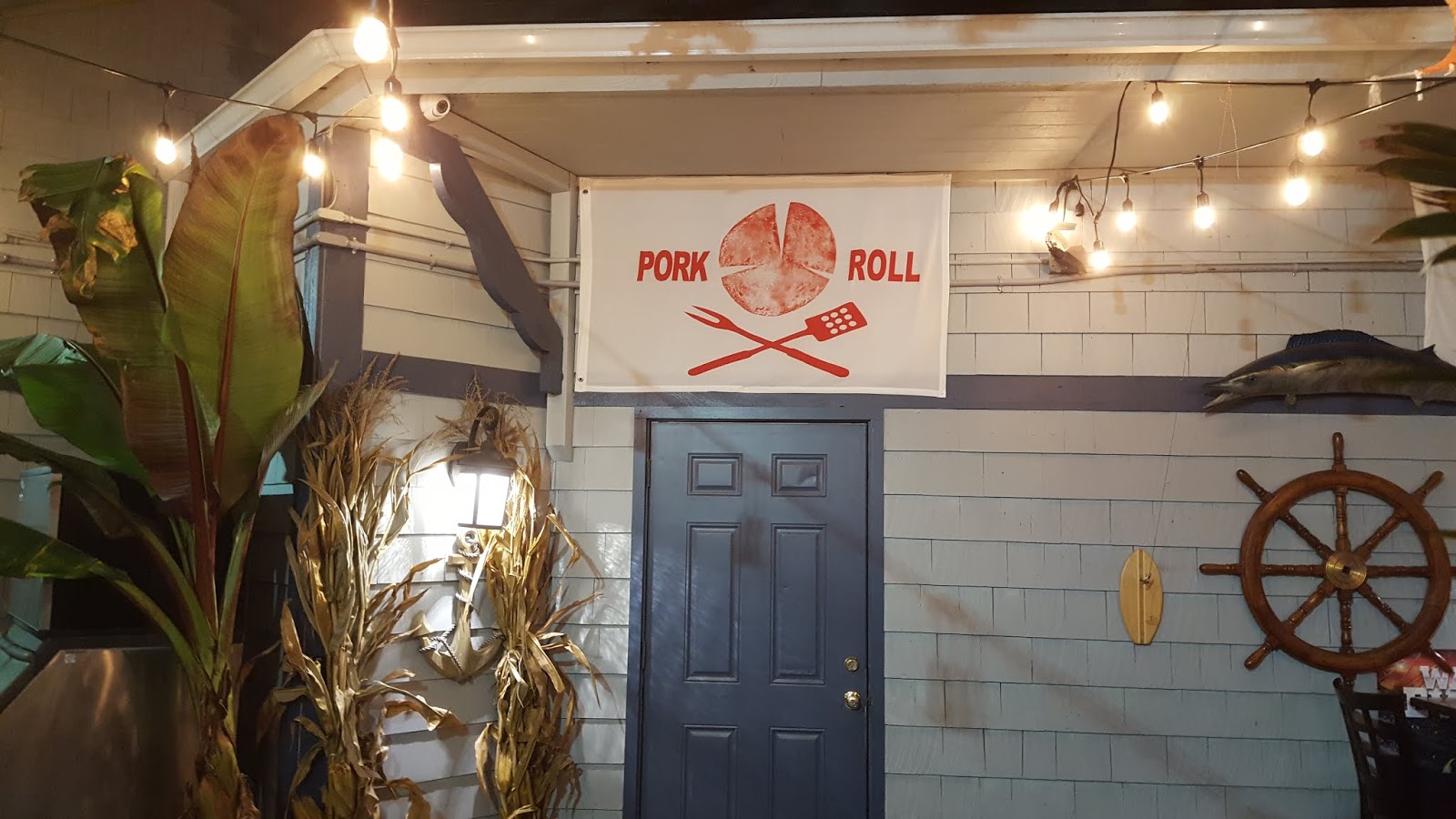
"You know you are in NJ when you see a Pork Roll banner!"
Picture taken near Marina Office


6 October 2019
Depart: Brielle Yacht Club 6:15
Arrive: Brigantine Anchorage, Atlantic City, NJ 3:30

Worried about being stuck in the slip until noon, I woke every two hours during the night to check the time. At 5:45 I was up and dressed and heading for the lines to start departure preparations. Note, sunrise came at 7:00, so we were up well before the sun. We had twilight, so we could see our way out. On departure, Clark checked the depth finders and could not get a reading on either one. We made it out of the slip without issue and were we glad to be out of there! I enjoyed watching the sun rise as I stowed our lines and fenders.

The marine forecast appeared reasonable for an outside trip to Atlantic City and maybe even Cape May, NJ. Since we were underway before 7 a.m., the 84 nm to Cape May was not out of the question. However, reality in the ocean did not match the prediction, and we found ourselves with a very uncomfortable ride. By 10:00 a.m., as we approached Barnegat Inlet, it felt to me like I had been out all day on the ocean! Clark said, "We need to bale out here", and in we went to travel on the inside.

With winds and waves forming a following sea, we were pushed this way and then that into Barnegat Inlet. Steering can be and was challenging to say the least in those types of waters. Finally, we got to the Barnegat lighthouse, things settled down, and we could enjoy the sights.


Windsurfer finishing up for the day.

We had a choice when we reached Atlantic City - anchor or marina. Clark and I decided to anchor in the Brigantine anchorage where we had stayed once before. "Home Too" had difficulty getting their anchor to hold, so they chose to stay at a marina instead. Just before we got to the turn off for the anchorage, Clark and I heard a nasty noise come from one of the propellers. We hit something but saw nothing before or after to give us a clue as to what we had encountered. 

With our schedule all out of whack, we were hungry early and decided to have an early dinner. Immediately afterwards I laid down on the couch and went into a deep sleep. I woke up long enough to make my way to my bed and then passed out again. 

7 October 2019
Depart: Atlantic City, NJ 11:20
Arrive: Cape May, NJ 4:45

Worried about the props and the marine forecast, Clark got up early and immediately started making phone calls and doing research on places to haul out the boat. In between those phone calls, he spent time doing research and making calls to find out about conditions for a boat like ours with a 4' draft traveling "on the inside" from Atlantic City to Cape May. He talked to a boat towing company about the route and the man he spoke to told him to forget it - too many shallow places and hazards! He did not find any places in the AC area capable of hauling a boat our size, so we needed to move on.

Since we are traveling with a buddy boat, we need to make joint decisions on go / no-go and when to go. After serious consideration, Clark thought that it would be worthwhile to get to Cape May today. The marine predictions indicate we will be waiting several days for a travel day. Clark and I both thought it would be much nicer to be stuck in Cape May than in Atlantic City. Clark offered to go out in the ocean and check out the conditions then report back to Franklin to make the final call.


On our way past the Absecon Lighthouse
hidden among the tall buildings

Still worried about the props and not having found any place that could haul a boat our size, Clark decided to dive under the boat to take a peek. He informed me, as we headed out into the rough ocean seas, that he planned to dive under the boat out in the ocean while he waited for Franklin to catch up. Clark does some things that I think are crazy dangerous and this idea has to be up there at the top of the list. Who free dives, i.e. no air tanks, under a boat in the Atlantic Ocean with 5'+ seas? The answer is ... Clark!!! 

At first he said we could just drift out there while he dove, but then he decided, thankfully, to drop an anchor. It was only 25' deep, so we let out about 150' of rode, turned off the engines (so he wouldn't die from carbon monoxide poisoning), and in he went. The water temperature was reported to be 68 so he wore a "shorty" wet suit for some protection. The good news is ... I still have a captain as he did not wash away or get a concussion from the boat coming down on his head. The other good news is that he could find no visible damage, i.e. bent prop blades or an object wrapped around a prop. 

I was very relieved, to say the least, when he was safely back on board the boat. Timing worked out well. By the time he was back on board, rinsed off, and dressed (around 12:30), our friends were just coming out of Absecon Inlet, and we could start heading towards Cape May together. We had some rocking and rolling, but nothing like the day before. The fact that the waves hit our forward quarter helped break their impact.

As we neared Cape May, the "Cape May Whale Watch" vessel haled us on the radio and told us that a humpback whale was up ahead of us on our course line. Clark thanked him for the call and said we planned to divert our course, so it should not be an issue.


Cape May Whale Watcher vessel

We could not see the whale from where we sat, but we could see the water spewing in the air from the spout. Earlier in the day, near Atlantic City, however, we did spot a whale. We saw the spray of water go up into the air as a big black body dove into the water. Cool!

A fishing trawler, "Elise G", entered the Cape May inlet just ahead of us. As we followed him in, we saw him raise his outriggers. Later, when we saw he had to go through a bridge, we understood why he pulled them in.


Outriggers up or it's a no go through the bridge!

With all the excitement and long hours on unfriendly seas, I told Clark I wanted dinner out tonight. Since the Lobster House is very near Utsch's marina, we opted to go there for a relaxing meal and conversation. 

It looks like we might be in Cape May for a full week waiting for the next weather opportunity to allow us to continue on our way south. There are certainly a lot worse places to have to spend a week! I told Clark to think of it as a "vacation".


Sunday, July 7, 2019

2019: NYC 4th July Fireworks

July 4, 2019
Sandy Hook Beach and Macy's Fireworks
Distance: 43 NM

It was a last minute decision to go to Sandy Hook beach and play in the sand and sun with the grand dudes. The other option high on the list was a day spent with neighbors as their guests at a beach club. We went with the boat option and found a spot where we could drop anchor and take the dinghy to the beach for Lily to play in the sand.


Our new captain - Lily

Fast Dinghy Ride

Papa Clark and Lily on Sandy Hook beach


Chris (son), Heather (his wife), and
Lily (our granddaughter).
Jack (grandson) and Evelyn stayed on the big boat.

Lily loves to play in the sand.

Chris, Heather, Lily, and Jack
on bow of Sunset Delight


After a fun time playing in the water followed by a nice dinner, the question came up could we do Macy's fireworks - we could see NYC as it was only 16 nm away. Clark's answer was a resounding "YES!" (he loves fireworks). Given that, we enjoyed a smooth crossing of Raritan Bay with the exception of a small encounter with a board and some debris. We anchored near New York City, off the Buttermilk channel, just south of the "Echo" security zone. This was far enough out to protect the grandkids' ears from the loud booms that tend to make them cry.

Approaching a hazy New York City

Multiple helicopters arriving in preparation for fireworks

Statue of Liberty at Sunset - gorgeous!

Lily and Jack with NYC in the background

Both the fireworks and the boat traffic with their associated wakes (except for law-enforcement boats) seemed subdued this year compared to our many trips in prior years. Clark likes to take pictures of the fireworks. Sometimes he gets a good picture - frequently, that is not the case.


Macy's Fireworks over the East River

Weird camera effects on Fireworks picture

Finally a decent picture of the fireworks and the river!

Lily managed to stay awake until the fireworks started. She must have been unimpressed, however, because no sooner did they start then she fell fast asleep in Heather's arms. Heather, Evelyn, and a sleeping Lily stayed below on the cockpit while Clark and Chris went up top to hear the synchronized music being played on AM radio 1010. After the show Chris came down and carried Lily, still dead to the world, to the guest stateroom and her makeshift bed.


At 10:15 Clark was still waiting for the "grand finale", but the rest of us finally convinced him that the Macy's display had truly finished about 10 pm. We pulled up anchor and slowly headed back towards New Jersey. Given our somewhat early departure time from NYC, it seemed we might arrive back home early, i.e. before 1:00 am, but as it turned out, our adventure was yet to begin.

As we headed back towards New Jersey, the Verrazano Narrows bridge lit up the river like day, but after passing under the bridge, it became eerily dark. The haze, no, more like pea soup fog, descended around us. It was black all around us except for the stars and aircraft in the sky and the green reflection of our own running light off the cloud bank. The cold air sent us scrambling for long sleeves and jackets.

The grandchildren were tucked into bed. Heather decided to stay in the guest stateroom with them to hear them if they woke. Evelyn, being exhausted from early-morning play with Lily, decided to lie down and rest. Chris and Clark were left manning the helm for the trip across Raritan Bay. They ran on an auto pilot track to the Sandy Hook channel with their eyes glued outside searching all around.

Hoffman and Swinburne Islands showed on the chart plotter and radar but were otherwise invisible at 1500' out. The plotted track would take us through Chapel Hill bell G"17", still invisible at 1000' out, so the track had to be altered to starboard to be sure it was well off the track. As they got closer, they could see the flashing green fog. At 450', they could finally see the marker abeam.

By now, we were idling at less than 1000 RPM, and the boats all around us were sounding fog signals, mostly off the port side. For safety, we also sounded ours, but it was so loud that it was in danger of waking our young and not-so-young sleeping passengers. Chris went below to see how everyone fared. Evelyn reported that that horn blasts had startled her several times. She had no idea we were dealing with dense fog and thought that there must be other reasons for the horn blasts. She had been trying to figure out what those reasons might be.

Happily, checking AIS, Clark found that the other boats around us had also slowed their speed. Sadly, our ETA was now predicted to be well after our anticipated 1:00 am. Passing by West Bank light and horn, 3 unlit nuns and a can had to be accounted for; Clark and Chris managed to find 2 of these closer aids. From here on, the visibility slowly improved allowing faster running speeds as the lights of NJ and Earle Pier slowly appeared. Checking AIS, about a mile out from Sandy Hook channel, we found ourselves on a collision course with an inbound freighter, White Hall. On a VHF call, we agreed we would slow to let him pass ahead.

Arriving at the Shrewsbury River channel entrance, an outbound boat appeared showing white and green lights thus making us the stand-on vessel. However, as the boat came closer, it became clear that 1) The red running light was extinguished and hiding the apparent head-on collision situation until the boat was very close. 2) A normal head-to-head meeting calls for a port-to-port pass, and this boat was cutting across our bow to starboard without any signals for another passing arrangement. 3) The boat was on the wrong, i.e. red, side of the channel squeezing between us and the nearby red marker. 4) The boat was traveling at a high rate of speed. 5) We needed to, and did, drop all speed and signaled a 5-blast danger salute on the horn. After which, the boat turned away after a delay that was too late to be effective for collision avoidance.

Following that incident, Clark attempted to call the boat on channel 13 and 16 to let them know their red running light was out. No name was visible, and they did not have an AIS transmitter operating, so hailing by name was not possible. No response was received on either channel when calling the vessel by location.

After this last adventure, we had the river to ourselves. It was at this time that Evelyn returned to the upper helm having missed the fog and the near-collision incidents. Although damp and chilly, the rest of the trip was uneventful. We finally arrived home some time after 2:00 am. It was well after 3:00 a.m. before all of us had climbed into our beds. Even so, we could expect the grandchildren to be up by 7:00!

(This story was written by Clark and posted to Facebook prior to Evelyn incorporating it into our travel blog.)

2019: Loopers passing by New Jersey

May - June 2019

Now is the time for members of AGLCA who are on the loop to be passing by NJ. Many go straight to Great Kills, Staten Island and bypass the north-central portion of NJ. Sometimes, we are honored by a visit of a passing looper. We are always happy to reconnect with our boating family.

This year we had the opportunity to connect with Karen and Mark on "Captain's Choice" (no picture), Denise and Mark on "Island Office", and Jim and Jo Ann on "Namaste Too".  We met up with "Captain's Choice" and "Island Office" in Staten Island, NY. We tried Andrew's Diner for lunch with the Gaudy's and enjoyed it so much, we went back with "Island Office" when they passed through.


Mark, Denise, Evelyn, and Clark
Lunch at Andrew's Diner in Staten Island, NY
On June 2, Jim and Jo Ann came to stay at our dock in NJ for a couple of nights, so we got a bit more time (and more food) to share with them.


Evelyn, Jo Ann, and Jim at
Dinner in Red Bank, NJ - "... say cheese!"
(Clark photographer)

Stir-fry Dinner at our home in Rumson
Evelyn, Jo Ann, and Jim
(Clark photographer)
Clark checked Nebo and saw that some folks we met at Faro Blanco this year had arrived in Atlantic City, New Jersey. He contacted them and invited them to stop by our place for a visit. They took us up on the offer and arrived at our dock on June 7th. With a commitment to meet up with family in Staten Island in a week's time, they decided to stay for a while.

We had a lovely time together including dining out at restaurants as well as combining our cooking skills to create great home-cooked meals. Our time together involved showing them some of central New Jersey's sights.

Red Bank -- Riverside Park

Asbury Park New Jersey

Robin and Charlie at the top of
Sandy Hook Twin Lights Lighthouse

Evelyn also took Robin food shopping at Delicious Orchards, which Evelyn described as an indoor farmer's market for lack of a better description. Robin loved it!

A couple doing the Great Loop that Robin and Charley knew from their travels anchored out at Atlantic Highlands during the McVey's stay at our dock. We invited them to join us for dinner at our home. The six of us had a delicious pot-luck dinner. Charley had rented a car given their length of stay at our dock, so he and Clark drove over to collect the other couple and return them to their boat after our evening together.

Charley and Robin left on the 13th to continue their second Great Loop adventure via the Erie Canal.


Charley and Robin, "The Lower Place",
traveling on the Shrewsbury River in
Monmouth County, New Jersey.

Also, in May and again in June, we got together with friends of ours who are planning to enjoy the Great Loop some time in the future.

Docktails on board "Home Too" in
Atlantic Highlands Marina, Atlantic Highlands, NJ
with Franklin and Cathy (future loopers)