Friday, November 11, 2022

2022: Hurricane Nicole Jacksonville FL

 8 - 11 November 2022

When we arrived at Lamb's Yacht Center, they assigned us a side tie in the fairway leading up to their fuel dock. This was fine with one negative exception that the bird feces on the roof next to our dockage blew off the roof with every gust of wind and landed on our deck. When I went out to look around the marina in the morning after our first night here, the starboard side of the boat was covered end to end in, thankfully, dry bird poop. I pulled out a broom and swept it clean. As I walked away, I could hear the sound of more falling to the deck I had just swept. I could see that I had a job for life if I so desired. 

Some folks we know from past encounters are also here at this marina. The folks on "Gypsies Palace" came over and invited us to go with them and some other boaters to a nearby Mexican restaurant for Taco Tuesday. We figured it might be our last opportunity to get out before the storm arrived. Six of us went to the restaurant just a short walk down the street. It was a fun outing, and we got to make new friends.

The next day, because Hurricane Nicole was predicted to be coming our way, the dockmaster decided to move us to a covered slip. We can lower our mast and did not expect to be in danger of hitting the ceiling of the slip with the mast lowered. Other, taller, boats were moved out of covered slips to allow them room to rise with the tide. I did one last sweep of bird doo, and we moved to the new spot for the duration of the storm.

We used fenders and fender boards when we had the side-tie assignment. After we got into the covered slip, we used lines tied to both sides and all corners of our boat to keep the boat from hitting either side of the slip. With so many lines, we did not bother putting out fenders or boards. I thought I might have difficulty getting on / off the vessel, but that turned out to never be an issue. 

After we had ourselves tied with extra, doubled-up lines and chafe guards on lines, we went for a walk around the marina to check things out. We were told that fire boats would be coming into the marina as the storm got closer, and sure enough, we saw them docking.


Other than the excitement of boat shifting in the marina, everything appeared pretty normal. We noticed some work boats in the marina. They are busy adding slips and making improvements to the facility.


Noticed this barge must have been here a while.
It is growing weeds in place on the barge itself.


We saw this crane on the barge. Clark remarked that it would make a lot of damage if it blew over in a hurricane!


As we lay in bed last night and this morning, we could hear the wind and feel the boat pulling on the lines. We were anxious to find out the storm status. We checked the radar and turned on the local news. The weather progress reports continued non-stop throughout the day. 


The storm came in just north of West Palm Beach. Friends of ours in Vero Beach spent a full day of hard work putting shutters up to protect their windows. A boating friend side tied to a dock in Daytona Beach worried about a direct hit. Folks on the west coast of Florida dreaded this storm covering territory already decimated by Hurricane Ian just over a month ago. 

Towns in the local area, such as on the St. John's River, still had high-water conditions from Ian and could not take any more water. The weatherman said that the wind would act as a cork in the end of the St. John's River and not allow water to flow out at low tide. The next high tide would simply add to the first. A storm surge of up to 5 feet above astronomical high tide was anticipated.


When we stepped outside, Clark immediately said he could smell something burning. He took off to investigate and came back with a report of a sailboat on fire on the other side of the bridge.

Normal view of bridge from LYC


The view from our side of the bridge was obscured by the smoke. We saw a video taken from the other side of the bridge posted later.

At the time the fire alarm was given, the fire boat had been hauled out of the water at Lamb's Yacht Center. Before the fire boat could go fight the fire, someone from the marina had to come and put the boat back in the water!


Fire boat rushing to the scene


At first we noticed a faint smell of burning plastic. As the fire progressed the smell was overpowering. When Clark came back from taking his pictures, he said even his hands smelled of smoke, and he was no where near the fire itself.

Video of black smoke before fire boat arrived ...


Video showing black smoke changing to white as fire boat does its job ...


Fire boat back at dock after the excitement is over

Meanwhile, these kids are oblivious to the fact there is a hurricane warning or a boat fire in progress.


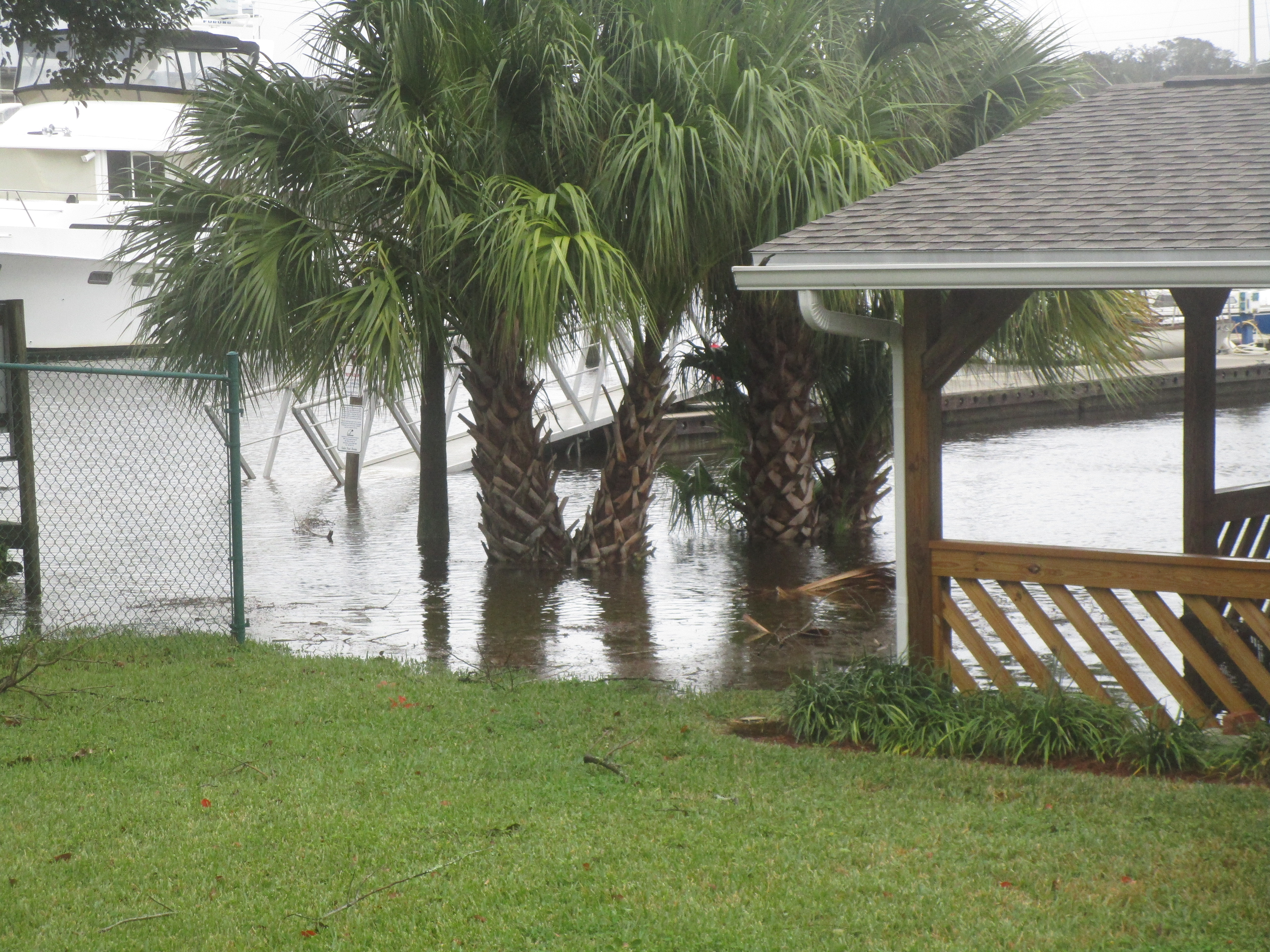
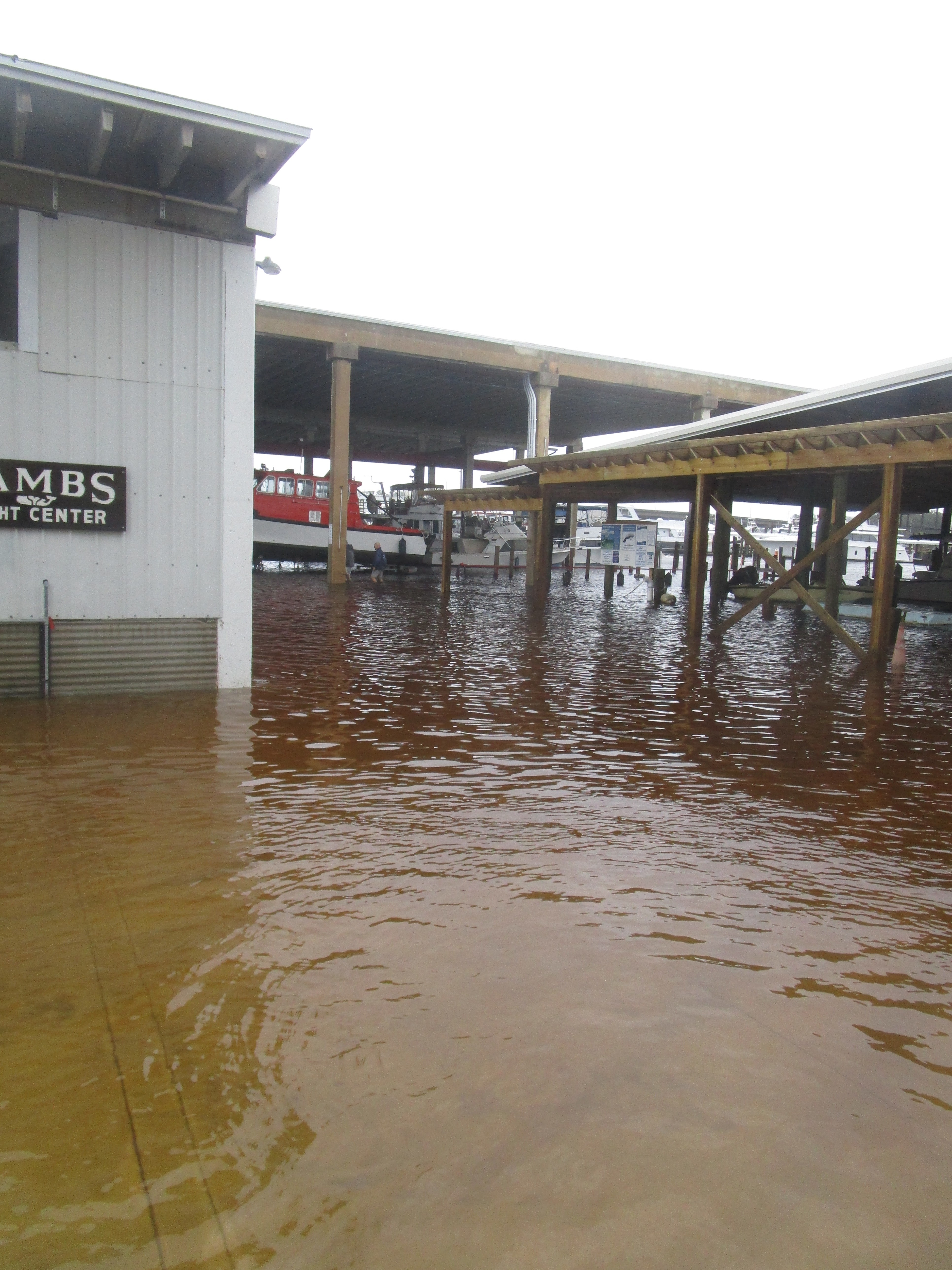
Other than the boat wiggling a bit in the wind - yanking on lines this way and that, we had no issues during the storm itself. Various sections of the marina flooded. High water cut off access to one of the docks, so anyone on a boat on that dock either had to stay on their boat or wade through water to get to their boat. 

Over and over on the news reports, people were advised not to go out and not to walk in the water since there would be no telling what might be in it. As we watched the news, we saw the cameras focused on one guy who was with his golf cart that was 1/3 submerged in the water. He tried driving it and then pushing it to no avail. Eventually he walked over and talked to the woman reporting the weather. 

He said he had come out for cigarettes and toilet paper. Clark wondered why he even thought a store would be open given the street was a river. The man said he was from Miami and was familiar with hurricanes. The reporter said they wondered why with several days' notice he had to wait to mid-storm to go looking for supplies.

At high tide we noticed some flooding in the marina. Clark and I walked around and took pictures.


Area under construction - water rising


Water level up


Walkway out to one of the docks here

As we waited for the storm to hit, we walked the docks checking out the boats - many with their masts lowered in the covered slips like us. I noticed "Chasing 80" across the way on the next dock over, so after checking out the dock we were on, we walked over to that dock. As we walked out to see them, I told Clark we could not stay too long as I did not want to be wading as we left the dock.


Later it's underwater

On our tour of the marina, we walked over to checkout the new dock next to Cedar Point. The walkway to Cedar Point was under water.


Normally we walk through here - 
note the picnic table.


I told Clark we could swing with our toes in the water.
He did not take me up on the suggestion.


The area below is where the boats are hauled and work is done. 


The area shown below was recently raised to prevent flooding under normal high tide conditions. It still flooded with Hurricane Nicole.


Other than looking at some extra water on the grounds of the marina, Hurricane Nicole turned into a non-event for us specifically. Even as late as Friday we noticed the water levels higher than usual, but we put our mast back up and took off the extra lines. As we picked up one set of lines to put away, Clark got a bit of a surprise.


Clark found a crab under our bow line.

The crab appeared to watch Clark and at some point he made a break for it and scurried away.

I find it frustrating to be in limbo. Earlier in the day we tried to call Enterprise to confirm our car rental for today. Since we decided to schedule pickup for Veteran's Day, Clark wanted confirmation that the place was open and could give us a car. After 30 minutes plus on hold waiting for an agent, I told Clark we should just use the courtesy car we had reserved from the marina, drive over, and either find them open and pickup a car, or find them closed and modify our pickup date. I refused to sit on hold the entire day with everything up in the air. 

Finally, I convinced Clark to drive to Enterprise. Surprise! We found them open and extremely busy. We got our car and returned to the marina. 

We thought that we would be moving our boat today - out of the covered slip used by another, taller boat as their usual slip. As of 5:00 the dockmaster had not returned Clark's call to get a new slip assignment. Once again we were in limbo as to what we should do. Finally Clark found a boat owner at the marina who had an alternate contact number for the dockmaster, and Clark got to talk to him. The answer - we are moving back to the side tie where we can look forward to shoveling bird doo off our walkway as it falls from the roof nearby.

The boat will stay put for a few days as we take care of business in New Jersey before continuing our travels towards the Florida Keys.

Monday, November 7, 2022

2022: Jacksonville to Ortega FL

 7 November 2022
Depart: Sister's Creek Free Dock, Jacksonville, FL 7:20
Arrive: Lamb's Yacht Center, Ortega, FL 1:55
Distance: 43 nm

We both woke up very early this morning probably due to changing back to EST from DST. Since we were both awake, we got underway 40 minutes ahead of the proposed departure time given by the captain last night. The sun was already up and the gnats were hungry as we got ready to depart for today's voyage. We decided to get going immediately and eat breakfast going along as we often do.

Sun coming up at Sister's Creek in Jacksonville, Florida ...


The dock was full last night, but already boats had left when we came out to work our lines.


Egret hunting for breakfast at Sister's Creek

We passed by all the normal, industrial views as we traveled the St. John's River towards Jacksonville. Having been by here multiple times, I did not bother taking pictures. Previous blog entries show all the usual sights.

I did spot something I had never seen before - a cow mural on the Acosta Bridge! There must be a story behind this. Turns out this spot on the St John's River used to be known as "Cowford" because the water was low enough here for cows to ford the river. The mural was done in January 2022 and explains why we have never seen it before. We were last here in December 2021.


It turns out that Clark is not the only one that can get a good railroad picture. I took the picture below because Clark was busy dealing with current.


We passed the military airport near Jacksonville, and shortly afterwards we saw a military plane taking off in front of us.


Instead of going directly to our destination for this evening, we first went to get fuel. We found a place on the St. John's River that offered a better price than anywhere else in the Jacksonville area. The only catch being that we had to travel about 4 hours out of our way to get the fuel. We had the current with us for the whole trip south on the St. John's River, so that helped make it worth our while.

The map below shows where we started this morning (at the heart) Sister's Creek and our final destination located at the star - Lamb's Yacht Center on the Ortega River.


The map below shows the extra distance we traveled to pick up fuel before docking for the night.

Blue dot / star shows the marina where we plan to stay.
Heart shows the location of the fuel dock we visited.

As we made our way towards the marina to get fuel, I noticed on the chart that we were heading for Switzerland! Surprise!!


Mandarin Holiday Marina had us tie to their fuel dock on our starboard side because they said we were too wide to come in for the port side. Our boat is 16' wide at its widest but that is not at the waterline, so we probably could have fit.


Other side of the fuel dock
where they said we would not fit!

We found lots of vegetation in the fuel dock slip we pulled into. We sat with our bow in the weeds as we fueled.


Weedy fueling spot


When we came in, I threw a line around a piling to hold us while we fueled. The woman working the dock quickly transferred the line to a cleat as she said the pilings were not to be trusted. They were weakened when Hurricane Ian came through the area. She showed me how bad it was by wiggling the piling at our stern. Part of the dock came up as she pushed the pole away from her! She said repairs are underway but not yet completed.


$4.999 per gallon diesel

We spent about an hour getting fuel and took on almost 400 gallons. Even at $5 per gallon, it added up in a hurry. The dial only went up to $999.99.  After that it rolled over to $000.00 and kept going. (Unlike when we fueled at Top Rack where they had to ring up our fuel charges multiple times because their meter stops at $999.99 and has to be restarted as a new purchase for any more fuel to be added.)


Lots of sailboats in this marina -
a bit surprising as we were concerned about
potential depth issues as we entered the area


Weeds in the slips!
Listing sailboat over a couple of rows
looks to be aground in the slip


Fish Camp nearby

Clark had to back out of the marina as the area was too narrow for him to turn around. I worried about the 20 knot winds catching him as he backed out into the river, but he had no issues. We had to watch for traps in the river as we made our way back north on the St. John's River to our marina on the Ortega River.  

The next couple of days may get interesting as we are watching a potential hurricane (Nicole) forming off Florida's coast. Fortunately, the marina gave us a spot to tie up that has us as well protected as we can be if a storm passes through here.

Sunday, November 6, 2022

2022: Charleston SC to Jacksonville FL

2 November 2022
Depart: Dewees Creek anchorage SC 8:15
Arrive: Bull River Junction anchorage SC 3:45
Distance: 58 nm


Sunrise on Dewees Creek, SC


Big boats traveling along at fast or even not-so-fast speeds can generate large wakes. I saw the guys below and initially thought they were standing on shore. No they were standing on their boat. 


Poling through the mud flats of SC

Our route today took us through Elliot Cut just south of Charleston, South Carolina.


Elliot's Cut, SC


Conditions vary as we travel south depending on whether we hit high tides or low tides. We got to see the mud flats in South Carolina today as we passed through on a lower tide.


With mud all the way up to the dock and beyond, some must go boating only on mid-tide rising to high.


a lot of mud between the waterway and this dock!


Can't get to this dock either


This "floating" dock is sitting on the mud.


so is this one

We found nothing new to look at today, other than the mud, until sunset.


3 November 2022
Depart: Bull River Junction anchorage 9:15
Arrive: Port Royale Landing Marina near Beaufort, SC 12:15
Distance: 16 nm

We have been anchoring out with no stops at marinas the whole way from home. Two times we stopped and were able to get off the boat, the rest of the time has been on the water. I told Clark that he had to find me a marina as my chore list was getting out of control. We planned yesterday's anchorage and today's stop to allow for time at a marina to "take care of business".

Normally, we need an opening when we pass through a swing bridge, but the one below had a 30' clearance when closed, so we did not have to wait. Others had gone through just in front of us, but Clark told the bridge tender we did not need it open, so it closed as we approached.


We decided to stop at Port Royale Marina where we have stopped previously and know our way around. When Clark called for a reservation, he asked if their waste pump-out station worked and they said no, so we had to make an alternate plan for that task. 

Clark got confirmation from the Beaufort town dock that their pump out worked, so we stopped there before going into Port Royale Marina. Our list of chores included: fill water tank, do laundry, buy groceries (bread mostly), hit the hardware store for sink parts, vacuum the boat, and bake applesauce cake for Clark's nightly desserts. 

We managed to do everything on the list except run the vacuum and bake the cake before 5:00 when we walked up to the marina restaurant, Marker 244, to grab dinner. I was ready to eat almost anything as long as I did not have to cook it. Clark chose a fried fish dinner and I got a burger. 


Marker 244 Bar and Grill

We sat at their covered dining area with a view of the boats in the marina and the local marshes.


After dinner, I baked Clark's applesauce cake which he eats almost daily for a midnight snack before going to bed. As the cake was baking, I ran the vacuum and drew a line through the last item on the list.

With all the chores completed, we were ready for an early start the next day for an ocean voyage to Georgia.


4 November 2022
Depart: Port Royale Landing Marina SC  8:15
Arrive: Johnson Marsh anchorage, GA 4:30
Distance: 71 nm

Clark did his research and analysis and decided that today would be a good day for ocean travel to get away from areas with shallow depths to worry about.  We got up in time to see a beautiful sunrise complete with sailboat passing by. 

Both Clark and I took sunrise pictures this morning. We both liked the sailboat. I did not know it, but he used my phone. I was a bit surprised when I saw more pictures on my phone than I remembered taking!


Clark knew he would go out in the ocean via the nearby Port Royale Sound inlet. What he did not know was which of the inlets further south provided safe passage for coming back in again. He called Sea Tow for local knowledge on Doboy Inlet, Sapelo Inlet, and St. Catherine's Inlet. He talked to two people who both told him that St. Catherine's was the only viable choice. We have come in Doboy in the past but that was before Hurricane Ian came by. We chose to play it safe and come in St. Catheine's. The blue dot shows us exiting at Port Royale and the red tear drop shows St. Catherine's Island.


We bypassed Savannah and the twisty turny waterway
in northern Georgia

The skies were hazy on the horizon. We could see on the chart plotter numerous boats that were anchored offshore most likely waiting to go up the Savannah River. Clark checked out the stats on one that said it was over 1200 feet long. 

Try as we might, we could not see a one of them with either the naked eye or with binoculars.


Numerous boats on AIS


Couldn't see one of them!

We had 3 to 4 foot seas on the ocean. Once we turned in a more southerly direction, the waves were coming on the stern and helped give us a push. Most of the day we had a good push from current and winds to help us on our way out of the Port Royale inlet, then south, and then in St. Catherine's inlet. 

With hazy skies, we had nothing much to look at for our trip other than ocean water. Clark told me to look for Right Whales, but we did not find any.

Coming in St. Catherine's inlet, we had a bit of excitement as some of the markers are missing. Fortunately, we found good water the whole way in with no difficulties.

Afterwards, we were chased by the disappointed seagulls who thought we had been fishing offshore.


We anchored in the marshes near St. Catherine's Island. I thought about the blog, but cell service was poor at best.


Sunset in the marshes
near St. Catherine's Island, GA


5 November 2022
Depart: Johnson Marsh anchorage, GA 9:15
Arrive: Cumberland Island anchorage, GA 6:25
Distance: 71 nm

It became windy during the night, and early in the morning we heard rain. We did not see the sunrise this morning.

As we traveled along, we saw a black cloud off the port side. Shortly afterwards we had a brief rain shower


followed by a faint rainbow.


People say "it's a small world". The boating world is even smaller. The other day we passed friends on a boat we met in Marathon Clark waved to them. (I was below and missed the event). Recently, we passed by a boat named "Blue Moon" docked at a marina. Clark saw the owners and waved (Once again, I was below and missed the event). "Blue Moon" is a trawler of the same make and model as ours. 

Today, we received a call on the VHF radio from a boating friend we met while doing the loop. Their boat was called "Island Office". Mark is now a delivery captain and was piloting a boat to be delivered in Florida. He called us on the radio to say hello - his boat was directly behind us on the waterway! (I did not miss this event.)


"Aria" passing by
with Mark onboard as delivery captain

A fellow boater recently posted a "Quiz" on Facebook related to the photo below ... "Who knows what this is?"   This structure is located at Kings Bay Base near Cumberland Island in Georgia.


It is located at the end of a long pier. 


Kings Bay Base is a naval submarine base.


The structure is a degaussing station where an electrical current is used to cancel out a ship's magnetic field.

We dropped anchor in the now very familiar anchorage at Cumberland Island. As per usual, a number of boats were there before us.  We headed off to one side to drop anchor and found a large number of dolphins circling the area. Based on what I could see of the fins, one looked like a mama with her baby. They never quite came out of the water far enough to get a good view.


Glad these were dolphins and not sharks circling!

We had plenty of interesting clouds to look at as we anchored.


Since it was so close to sunset as we anchored, we got to see the sun setting and the moon overhead simultaneously.

Moon over the docks at Cumberland Island


Moon over an anchored sailboat

Sun going down at Cumberland Island ...


6 November 2022
Depart: Cumberland Island anchorage, GA 9:10
Arrive: Sister's Creek Free Dock, Jacksonville, FL 12:30
Distance: 26 nm

We went to bed with dark clouds in the sky and woke up to more of the same this morning. Last night Clark told me the plan for today was to wait until 11:00 to leave the anchorage to avoid fighting current for ages along our route. As I leisurely ate my breakfast, he asked how soon I would be ready to leave because he was ready to get underway. 

Huh? I guess we had a change of plans while I was sleeping. The new plan he told me was to leave now and stop at the free dock at Sister's Creek to have lunch and then continue on our way when the current was more favorable. Good thing I did not make any big plans for my free time this morning. 

As we traveled towards Jacksonville, we had clouds mixed with sun and occasional rain showers. 


We passed by the plant shown below through a "no wake zone". I asked Clark if they were manufacturing sawdust because that is what I could smell in the air.


Big pile of sawdust?

We did not have rain here but we could see it raining up ahead.


Clark gets excited when he sees railroad bridges. He wants to try to take a photograph looking down the tracks. Mostly he misses one way or the other. He was motoring towards the bridge and fighting the swirling eddies when he realized he could get a railroad tracks shot. I said go for it and took the helm while he ran with the camera to try his luck!


Clark got the shot as he hit the tracks dead on!

Clark said we should eat lunch when we got to Sister's Creek. At 11:30 (12:30 DST) my stomach said it could not wait. I checked the map and saw we had a long way to go to get to Sister's Creek, so I fed us! We finally got to Sister's Creek dock at 12:30! Glad we ate when we did!

Clark figured we should hang out at the free dock for about two hours and then continue on our way. I suggested that we stay put. As we sat at the dock, other boats came in, and Clark ran to help them tie up. One couple stopped just to walk their dog. When they left, they told him they were headed up the St. John's River, so Clark asked them to give him a call to let him know what the current was like. 

We planned to prepare to leave at 2:30, but when they called and said they had 3 knots of current against them, Clark thought about the timing and decided we should just stay at the free dock and leave early in the morning. With that wonderful news, I decided to take time to work on the blog which took the rest of the afternoon to complete.

Tomorrow we head to Ortega to stay in the Jacksonville area for a period of time before we continue our travels towards the Florida Keys.