20 April 2023
Depart: Fairfield Harbour private dock 8:35
Arrive: Ocracoke, NC dock at National Park 3:45
Distance: ~ 58 nm
Conditions: perfect
Yesterday, Clark did some trip planning regarding where we should go, how far could we get, etc. This morning he surprised me with, "How do you feel about going to Ocracoke?" This option bypasses the Pongo River, Alligator River and the canal that joins them. It sounded like a great detour from the norm to me. Calm weather made this option viable.
A couple of folks were playing in the waters - one boat and one kitesail.
We had wind pushing us hard off the dock as we attempted to tie up. Folks from a sailboat that were docked there helped us come in. It took about 20 minutes to get us where we could get off the boat. Thank goodness for helpful boaters.
I had put in a request for a bike ride tour of the area. That was the plan, but it took us another 20 minutes to figure out how to use the QR code to get the app to sign in and pay for the slip. We have the Senior Pass for the National Park, so we got a substantial discount on our dockage for the night. Finally around 4:00 we were able to get on our bikes and go for a tour of the area.
 |
| We docked near the ferry. |
 |
| Ocracoke has Blackbeard pirate history |
 |
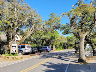
| Tree lined street in Ocracoke |
After checking out the map of the area, Clark wanted to bike the road around the water. I wanted to see the historic British Cemetery Road.
 |
| Which way do we go? |
Clark's chosen path gave us some good water views.
Although it seemed out of place, I spied some cactus plants along the roadside.
We could see the lighthouse through the archway of a fence.
After seeing the lighthouse, we continued our exploration of the area.
We passed the ice cream store on our way to see the lighthouse. As we made our way back towards the boat, we decided to sop for a treat before continuing our tour.
 |
| The Fudge Shop |
Next to the ice cream shop we found a gift shop.
It had numerous, fun whirligigs on display.
After the ice cream, we walked around the area near the ice cream shop.
Then it was time to go check out my choice - British Cemetery Road.
From the description on the map I thought I would see older homes. Instead, I found several old cemeteries and the one in particular that gave the road its name.
 |
| Only 4 bodies were found after the German sub destroyed their ship in 1942. |
Map showing blue dot where the boat is docked.
Map showing the roads in the area.
Due to eating ice cream late in the day, I waited until 7:00 to start dinner. As we ate I had one eye on the time because I did not want to miss the sunset. The pictures near the boat were not great, so I convinced Clark to go for a walk to get a closer look.
Clark decided to play around with taking a picture of the sunset.


No comments:
Post a Comment