30 October 2021
Depart: Bull Creek Anchorage SC 8:15
Arrive: Wallburg Creek Anchorage near St. Catherine's Sound, GA 2:45
Distance: 50 nm
Conditions: Sunny, Chill in the air
I had time this morning while I ate breakfast to watch the sunrise.


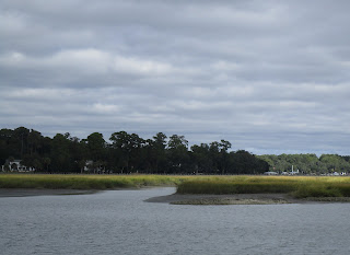
The last few miles we traveled in South Carolina were mostly marshland. The sun was shining on the marsh grasses making them glow a golden color.


Pictures taken on Field's Cut in South Carolina.

 |
| Long Dock to Nowhere - no house, nada |
 |
| Bird Haven near water running off of a huge pipe |
 |
| Dredging Operation In Progress |
After crossing the Savannah River, we found ourselves in Georgia and watching out for dangerous rocks on both sides of the waterway.
 |
| Sign says "Danger Rocks" (no kidding!) on the port side |
 |
| rocks on the starboard side of the waterway |
As we approached Savannah, I wondered if I was seeing deja vu. The bridge in the distance looked like a twin to the one we saw as we approached Charleston, SC.

In the distance I could see a colorful object. As I watched it moved, and I realized it was a container ship heading towards the Savannah River and then presumably out to the ocean.
 |
| Evergreen Container Ship looked like it was traveling over ground |
As we cruised, we could see Savannah off in the distance, but we never came close enough to see much of the city. The next place of interest we passed by was Thunderbolt. The ICW guide says that the name of this place comes from an Indian legend that says that a lightning bolt struck here and opened up a freshwater spring.
 |
| Thunderbolt Marina -- we have been here in the past |
Clark saw a "nice looking boat" and asked me to take a picture.
 |
| "Shane Winston" fishing boat |
Later I saw a boat that I liked - not the boat really - the name!
 |
| "Balderdash" |
That boat was located at the Isle of Hope Marina. This is another marina we have stopped at in the past. Specifically, we stayed here on "Sea Moss" when we were on the Great Loop and visited Savannah from here.

After passing Isle of Hope, we once again found ourselves in marshland with mudflats as the passing scenery.
 |
| Mud flats along the ICW |
 |
| View at low tide along the ICW in Georgia |
We saw lots of trees - dead and alive.


 |
| Historic Site Marker on Beach |
We did see some homes now and again.
 |
| Sun shining brightly on these homes |
We arrived at the Wallburg Creek anchorage that Clark had selected for tonight's target stop mid-afternoon. We had a chance to "chill" for a while - something that has not been a common occurrence on this voyage.
 |
| Sunset at Wallburg Creek Anchorage near St. Catherine's Sound in Georgia |
31 October 2021 -- Happy Halloween
Depart: Wallburg Creek Anchorage 8:15
Arrive: Cumberland Island Anchorage 6:05
Distance: 80 nm
Conditions: Chilly 54 degrees in morning => near 70 later in day
We were up in time to see a sunset, but it never happened. The hazy sky turned a very pale pink, but we saw no sun until much later in the day.
Views today closely resembled marshland scenery we saw yesterday. Traveling at low tide in Georgia is definitely a challenge.
 |
| Birds wading in the waterway |
 |
| More muddy sides |
Our timing was particularly bad to find ourselves navigating Little Mud River at low tide. Using the sonar charts, Clark picked a path near the red marker only to see the depths drop rapidly towards zero until the depth finders could read no depth at all. Yikes! We did not bump bottom.
Clark put the boat in reverse and backed out past the red marker to give it another try. Looking at online input from other boaters, Clark read that he should give the red marker a wide berth! Even so, we watched the numbers like hawks. At one point we had 6 inches of water below the keel. We breathed a sigh of relief when the depth went back up to 12 inches of water below the keel.
We traversed this section of the waterway at minimum RPM yielding 4.5 knots. It felt like it took forever to get to the end of this stretch of water.
After the excitement of Little Mud River, the trip became tedious. Clark can drive the boat for hour after hour, but I get sleepy. Today I decided to lie down on the bench seat and read for a while. Eventually, I gave up on the book and just lay down and listened to the talk radio show that we had playing.
Periodically Clark would say something about other boats or sights we were passing. At St. Simons Sound, Clark looked for the shipwreck that has been there for years. The boat was cut into pieces and removed section-by-section. The only indication a wrecked ship was here is the structure placed here to help with the removal of the wreck.


When we discussed today's travel, we estimated about 8 hours of travel time. Having left this morning's anchorage just after 8 o'clock, I figured we would arrive at our destination around 4:00 or 4:30.
Finally, as it got late into the afternoon, Clark pointed out Cumberland Island off to our port side.
 |
| Lighthouse on Cumberland Island |
 |
| Beach at Cumberland Island |
We had waves and rocking in the waters of St. Andrews Sound. Looking at the shoreline of Cumberland Island, I saw not one but two green buoys lying on their sides instead of floating on the water.
 |
| Green Buoy beached on Cumberland Island |
The chart showed a mess of waterways going every which way. I could make little sense out of where the anchorage was given the picture I was looking at on the chart. Multiple times I asked the equivalent of "Are we there yet?" I kept thinking we had to be close and then being disappointed to see we still had a long way to go. Since I was tired of asking and I am quite certain Clark was tired of hearing my "are we there yet?" questions, I decided to go below and cook dinner to make good use of my time and the electricity generated by the engines while I had it.
We finally pulled into the anchorage a little before 6:00. It had taken a lot longer than the 8 hours we anticipated. Having to crawl through skinny water today for long stretches of time really ate up the minutes. I would definitely prefer to expect 6:00 and arrive early than to expect 4:30 and arrive at 6:00. On the bright side, by the time we pulled into the anchorage, I had dinner ready.
Pulling into the anchorage area, we found a number of boats there before us. Clark counted something like 18 boats including us anchored there. Clark found a spot away from the masses and dropped anchor. By the time he had the "boat put to bed", I had dinner on the table.
Since we had no visible sunrise this morning, I hoped for a show tonight, but it did not happen. We saw nothing worth taking as a sunset picture.
No comments:
Post a Comment