10 April 2024
Depart: Alice Town, Bimini, Bahamas anchorage 8:20
Arrive: Private Dock, Pompano Beach, FL 3:00
Distance: ~ 55 nm
Conditions: Choppy / Waves
Before we left the coast of Bimini, I took out my cell phone and took a few pictures.
 |
| Sunrise over Bimini |
 |
| Cruise Ship: "MSC Magnifica" anchored off Bimini |

Every day, except Sundays when no reports were given, Clark rose at 6:30 for the Chris Parker weather report. This was particularly of interest when determining when to cross open water to return to the states. He took copious notes on the conditions throughout each day.
 |
| Crossing options: Monday - Wednesday |
 |
| Details for crossing on 10th April |
Any day the wind has a northerly component is a bad day to cross as the wind fights the Gulf Stream and the waves become short and steep. Although it showed waves and strong winds for Wednesday, we had SE winds pushing us, so not so bad as it may sound.
To make the voyage back to the states, we had to take the flow of the Gulf Stream into consideration. Crossing the Gulf Stream adds several knots of speed in a northerly direction. Crossing at the wrong heading will land a boat somewhere they had not planned to go.
The charts below show two lines - a red one and a green one. The red line is the course heading. The green line is the actual direction of the boat (all factors considered). Before we got well into the Gulf Stream, the two lines were in close proximity to each other. (Chart I) Once we were in the Gulf Stream (Chart II), the way we pointed the boat and the direction we actually traveled differed considerably. The boxed X on the black line marks our destination.
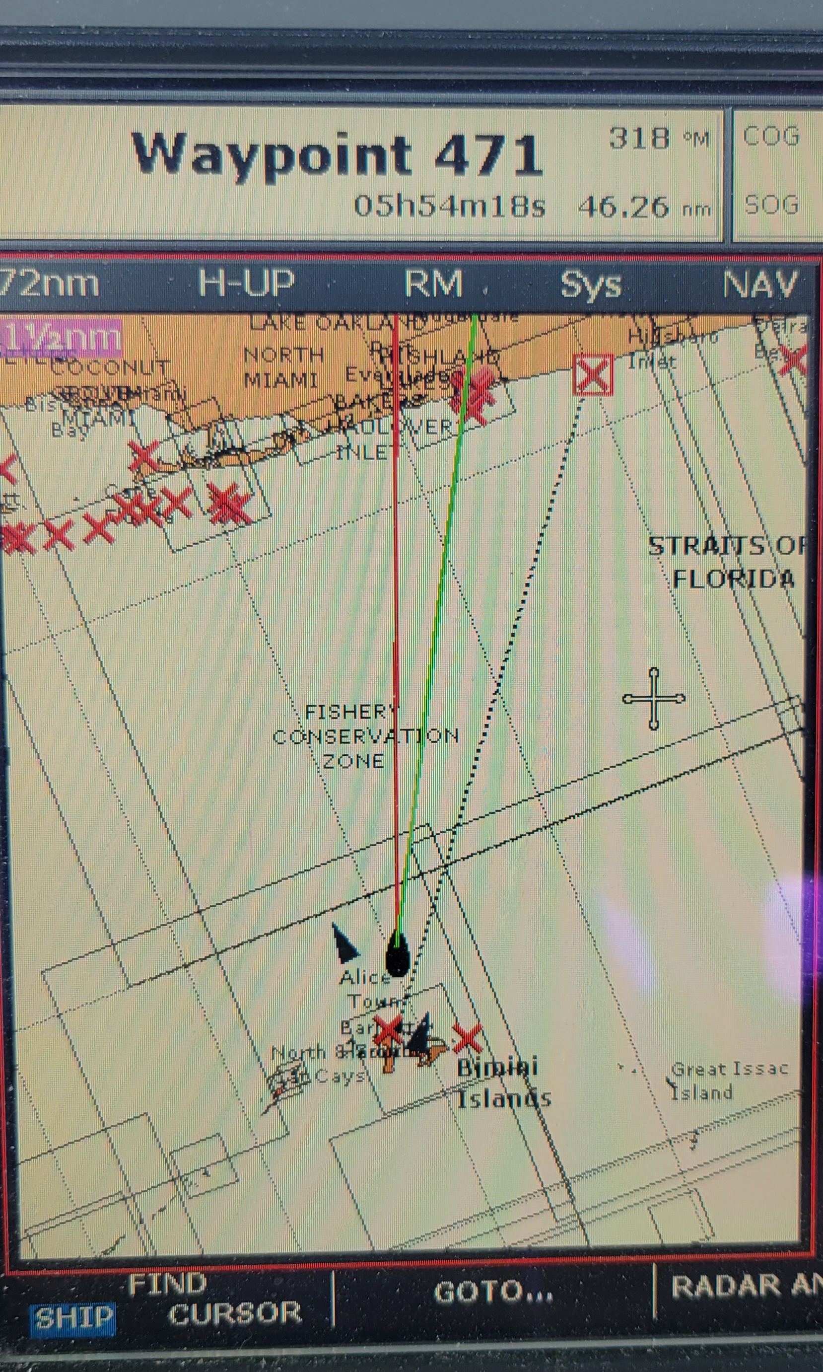 |
| Chart I: 6 hours of travel time remaining |
 |
| Chart II: a little less than 5 hours of travel time remaining |
After more than 6 hours crossing the Atlantic Ocean, we arrived at the Hillsboro Inlet near Pompano Beach exactly where we wanted to be. The ride into the inlet was a little wild as we rode the waves.
 |
| Hillsboro Inlet up ahead |
 |
| Lighthouse in view |
The waves crashed on the rocks of the jetty as we came in.

As we fought our way in the inlet, we saw a lot of people taking advantage of the windy conditions.
 |
| Wind surfing |
Once we got in the inlet, the water settled down. Phew!
 |
| Looking back at the wind surfers |
 |
| Sea Tow ready for anyone in trouble |
As we looked out at the ocean, we saw a sailboat coming in the inlet. First the boat was heading towards us, then sideways, and finally pointing back out to sea. Clark thought perhaps they were in trouble, but it turned out that they decided to stop there (in the wild waves) to take their sail in.
 |
| Taking down the sail in rough waters |
As we went through the inlet bridge, they were close on our tail -- perhaps a bit too close for comfort. Once we turned onto the ICW, Clark waved them by us to get them off our stern. The port of call showed as London (I assume England). They were clearly seasoned sailors in a hurry to get somewhere.
 |
| Hillsboro Inlet Lighthouse |
Our friend's dock is close to the inlet. We transited the bridge at 2:30 and were tied up at our friend's dock at 3:00.
 |
| View at our friend's house |
With a sigh of relief we greeted our friends. The places we saw in the Bahamas were interesting but the trip was exhausting. Every day we had to think about where we could be or needed to be due to the weather. A couple of times, even when we did not move to a new town / island, we picked up and moved to a new anchoring spot because of a wind change or expected wind change that would be less protected or would put us in the shallows. We dragged anchor once when the anchorage was crowded and we were anchored on a down slope.
This is our second voyage to the Bahamas, and I kept asking myself (and Clark), while we were there, "Why do we keep picking years with "el Niño" to go over there!?
April 11, 12, 13, 14
Since we arrived in Pompano Beach on Wednesday, the 10th, we have not gotten up at 6:30. We have not moved the boat. We have been chillin', and it's felt so very good to relax! Our most important decision each day has been what to have for dinner.
I got caught up on laundry, added some groceries to the ship's stores, and even managed to run the vacuum cleaner through the boat. Clark and his friend Steve have been working on boat projects together. Steve had a boat the same model as ours in the past. A couple of times he has given Clark boat parts that he took from his boat as spares.
This trip he gave us two old VHF radios the same model as our broken one at the lower helm. Our lower-helm VHF radio lost its ability to display the channel number. We only knew when we were on Ch 16 and could not in reality change to any other channel and know for sure that we were on the correct channel based on counting detents.
A very good friend gave us his old VHF radio that had stopped working for him. Clark fixed that up and left it sitting on the lower-helm station, i.e. did not mount it for permanent use. We used that radio throughout our trip in the Bahamas as we could tune in the the Cruisers' Net when offered without having to go up to the upper helm. It also allowed us to have one radio on 68 or 72 for the net while the other was on 16.
The night Clark got the 2 radios from Steve, he was up until almost 2:30 in the morning cannibalizing the three VHF radios (Ours plus the two from Steve) and building himself one good, working radio. Clark said it was not an easy job to do. One might wonder why he bothered rebuilding a VHF radio from parts when a new one can readily be bought from West Marina. The answer is that the VHF is mounted in the wall. No other radio nicely fits in the same footprint of the wood panel and is also electrically plug and play for the power and NMEA networking connections for the GPS data.
 |
| (re)Mounted VHF Radio |
Whenever we visit Steve, Clark and Steve alternate boat projects to work on. This trip Clark helped Steve set up his laptop with a GPS capability so that he can know where his boat is on the chart displayed on the computer. After a lot of thought and research, Clark came up with a simple solution that gives the computer GPS capability. They tested it by walking around the house, and the computer knew where they were. Eureka!
While here we visited a couple of stores that are not our "norm". Steve took us to Costco one day for food shopping. We do not have a membership and have not been in a Costco in over 20 years. It was a novel experience.
He also took us to visit the Boat Owner's Warehouse (www.bow.com), which we were unfamiliar with. It is a nice alternative to West Marine. Clark wants one in central NJ now. We also visited a huge Ace Hardware while here, and Clark found the metric cap screw he needed to fix the windlass that broke. All told it has been a very productive few days.
I rate this "marina" 5 *s. The dock comes with rides to whatever stores we need to visit (and some we did not even know about), includes a courtesy car if needed, and best of all, it allows us to spend time with great friends.
We leave here tomorrow to start our trek north up the ICW.
No comments:
Post a Comment