8 May 2023
Depart: Sunset Lake anchorage, Cape May, NJ 6:40 a.m.
Arrive: Atlantic Highlands, NJ anchorage 8:20 p.m.
Distance: 115 nm (a new record length)
Conditions: Calm seas < 2 foot, Some clouds, i.e. PERFECT
We debated last night whether we should "go for the gold" and aim to get all the way up the Jersey coast in one day or split the day and spend one more night at Barnegat. Clark knows of no anchorages at Manasquan, so that ruled out that option.
After agreeing that we could take turns napping on the trip, we decided we would leave the decision for morning. If we could get up at 6:00 to get going, it would be a one-day trip. If we needed to sleep in, two days would be the outcome.
We were both awake at 5:55, before the alarm, and ready to make the day-long trip. With such an early start, we even got a glimpse of the sunrise - an unusual event for us in the spring.
 |
| Glimpse of Clark prepping to raise anchor |
It is interesting that in several directions, we see homes and tall buildings. Then, turning around to face the other direction - marshes!
To access Sunset Lake we needed to go through a bridge with a specified vertical clearance of 23 feet. We only need 22 feet, so we were good. Given it was near low tide when we came in and when we departed, the height board showed around 25 feet, so easy peasy!
 |
| Two-mile bridge in Cape May, NJ |
Anchoring in Sunset Lake added a bit of distance, about 2 nm, to our path out to the ocean, but we both agreed that it was a nice spot - well-protected, isolated and just a few fish pots that did not interfere with our ability to pick our anchoring spot.
Clark had tried to message another boater yesterday prior to arriving in Cape May to find out how hard it would be to anchor in our normal spot given the dredging activity. He did not reply until today when we were already on the ocean, so we found out for ourselves last night that for any spots that could be used for anchoring, someone had beaten us to that spot. This sojourn into the unknown Sunset Lake turned out to be a great alternative.
As we came out from under the bridge, I could see the USCG tower in the distance marking where we normally drop anchor.
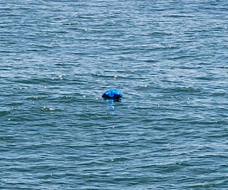
The trip on the ocean was in one word uneventful. The most we had to worry about was telling the autopilot to target our next waypoint on the trip north. Many birds "pretended" to be traps but flew away before we got close enough to care. We thought we saw one fish trap, but it turned out to be a balloon.
I wish people would understand when they release balloons into the air, they pollute the environment somewhere. In the ocean it can be deadly to sea creatures. The balloon was too far away from us to rescue it from the ocean.
 |
| Balloon masquerading as a fish trap |
After close to 12 hours on the ocean, we got a glimpse of "home".
 |
| Verrazzano Narrows aka VZ Bridge, NYC |
The trip from the shoals at Shrewsbury Rocks near Seabright, New Jersey up and around the tip of Sandy Hook, NJ seems to be the longest leg of the journey. If an inlet existed in Seabright, we would be home in 30 minutes. It does not, so it takes several hours to complete our trip home.
We finally rounded the tip of Sandy Hook and got a view of the Sandy Hook lighthouse.
 |
| Sunset over Earle Pier |
 |
| Sunset over Atlantic Highlands anchorage |
19 May 2023
Depart: Atlantic Highlands, NJ anchorage 9:55
Arrive: Rumson, NJ home dock 11:20
Distance: 9 nm
Conditions: No rain although some potential predicted
As we left the anchorage, I pointed out some danger markers and mooring markings that Clark had not noticed. Clark called the "Sea Wolf" tug on duty there to ask for directions navigating around the dredge site located by the channel. He told us to go all the way around all the moorings and danger markers and make a U-turn back into the channel. Good thing Clark called on VHF to ask!
 |
| Tug "Sea Wolf" |
Some houses in this area are built on steep hills to get the best view of the ocean and NYC. Unfortunately, as shown in the picture below, some erosion has occurred over the years. I would not want to live in the house on the right!
 |
| Tannish-brown area under the house on the right is where the erosion is showing the worst |
When we see the building below, we feel like we are already home. It has been located here as long as I can remember. When I first moved to New Jersey, one could drive on a road on the ocean side of this building. There was a site there where we could park and use machines to view NYC. Erosion of the hill closed this park as it fell away over the years. Now this area is closed to traffic.
When we got to our dock, I found the remains of a long-ago dead fish as well as several spots of goose poop, and thus the work of moving back into the house begins. First job, clean the dock!
Normally, we arrive home late at night and spend one additional night on the boat before moving into the house. Since we arrived in the morning, I asked Clark if we would follow tradition and sleep one more night on the boat. He nixed that idea right away, so while he turned the house back on (water, hot water, etc.), I started packing bags of essentials to move off.
Before anything could be carried up to the house, however, I insisted that I needed to remove dust covers, dust, and vacuum first. After cleaning the house, the moving began. I cannot count the number of trips we made from the boat to the house loaded down like pack mules.
People frequently ask us why we still have a house. I tell them is it because it has a free dock. It is when we need to load / unload the boat that I am happiest that we dock the boat behind our house!
Thus ends the 2022-2023 boating season. From this point on, it is routine - fix boat things (Clark's list), grocery shop (Ev), mountains of laundry (Ev), massive amounts of gardening (Ev), work on house repairs (Ev's list), etc. etc. etc.


