Thursday, November 30, 2017

Kitty's Dock Cape Coral to Fiddlesticks in Punta Gorda

Wednesday 11/29/2017 – Thursday 11/30/2017
Depart: Kitty’s Dock – Cape Coral, FL 10:20
Arrive: Fidler’s Dock – Punta Gorda, FL 4:15
Distance: 41 NM

While waiting for the tide to come in high enough to allow us to leave Kitty’s dock in Cape Coral, we sat on Kitty’s screened-in porch enjoying the morning. At 10:00 we walked down to the boat and started to prepare for our trip to Punta Gorda.

Weaving our way out of the lagoons, we passed a couple of fishermen sitting on the dock.

Fishermen on the docks?


No - little ceramic figurines posing!

 
To get to Punta Gorda, we had to travel southwest to exit the Caloosahatchee River, pass several islands (Sanibel, Captiva, and Cayo Costa) , and then travel northeast into Charlotte Harbor. Unfortunately, we were traveling the same direction as the wind, so we had no breeze. That combined with a bright sun shining on us made for a very hot ride. To make matters worse, we traversed a long “Manatee Zone – Slow Speed” zone. Speed boats, trawlers and sailboats formed a parade as we very slowly passed through the Manatee Zone.


"Manatee Zone" boats on parade


Watching the fast boats in front of us, we knew as soon as the slow speed zone ended as they took off “like bats out of hell”.

I do not know how he does it, but Clark can recognize certain boats from far distances. Whenever we are traveling and he says, “Is that a Mainship?” 99.99% of the time it is a Mainship. Today he saw a vessel coming towards us from off in the distance and said, “Is that a Krogen Express?” I looked and said, “It might be.” As it got closer and closer, it became clearer and clearer that it was indeed a Krogen Express. When the boat passed us, we saw her name – Black Swan, and she had a similar dark-colored hull. It was almost like looking in a mirror. How exciting to see a sister ship! Of course, we waved madly at each other as we passed.

Thirty minutes or so after we passed the Krogen Express, we saw a tour boat coming into the main channel from the direction of Cabbage Key. As the boat turned in front of us, Clark distinctly heard the narrator say the word “cheeseburger” and knew he was talking about Jimmy Buffet’s “Cheeseburger in Paradise” supposedly made famous at Cabbage Key.


Lady Chadwick
Tour Boat out of Captiva Island


We followed the tour boat for a relatively short distance – behind and slightly to their starboard side. All of a sudden, we heard the captain of the tour boat calling “Black Swan, Black Swan this is Lady Chadwick”. Clark and I both looked around to see if we could see Black Swan. After Lady Chadwick’s second call to Black Swan, it occurred to both Clark and me that the captain thought we were Black Swan! I told Clark to respond, which he did.

The captain confirmed that since we were a similar-colored Krogen Express, he thought we were Black Swan. He complimented us on what a beautiful boat the KE is. Then he told us he needed to make a turn down a channel to the east, so Clark backed off on speed and moved to Lady Chadwick’s port side to get out of their way.

From the level of dolphin activity we get with Sunset Delight, it’s pretty clear that they love traveling at our speed of about 10 mph. Today we had two sets of dolphins – one on port (3 dolphins) and one on starboard (4). Often they turn to look at the boat to verify they have an audience!


Dolphin fun!!


Clark noted that even though we had changed directions on today's travels, it appeared that the wind changed with us to keep us miserably hot. At 2:00, we finally reached the end of Cayo Costa island and turned towards Charlotte Harbor. With 21 miles to go to our destination in Punta Gorda and an average speed of 8 knots, that meant we still had more than two hours to go.

Once we entered Charlotte Harbor, we found lots of open water, minimal boat traffic, and lots of dolphins to keep us company.  Thankfully, eventually, we got far enough into Charlotte Harbor to find a breeze and start to cool down. Finally, just before 4:00 we arrived at the channel to Clark's friend’s house.


Channel into the mangroves at Punta Gorda, FL

Channel through mangroves

Following Route to Fiddlesticks

Jim and Carol, from a Mainship named Fiddlesticks, greeted us at the dock and helped us raft up, i.e. tie up to their boat.  Being both engineers and boating enthusiasts, Jim and Clark started talking as soon as we got there and hardly stopped long enough to catch a breath! These two have known each other online for many years. This is the first time they have ever met in person!

After we got Sunset Delight settled in, Jim and Carol drove us into town to eat at an Irish Pub. They looked to have a great menu, but due to it being Trivia Night, the restaurant was so loud we would not be able to have a conversation. We left there and went to an English Pub that resides in an old-time Ice House. I had their so-called famous Fish and Chips and Clark had Cottage Pie.


Night Sky at Punta Gorda, Florida

Osprey sitting at the top of a sailboat mast
to get a "bird's eye view" for an evening of fishing!

 On Thursday, while Clark and Jim took Sunset Delight out to fill up the fuel tanks, Carol and Ev went shopping - Walgreen's, a bank, Home Depot, Publix, and West Marine. After we all got back to their home, Carol made us a nice lunch, and we chatted away the rest of the afternoon. With non-changeable dinner plans, Jim and Carol went out while we cooked and ate on our boat.


Tuesday, November 28, 2017

Fort Myers Anchorage to Kitty's Dock in Cape Coral

Monday 11/27/2017
Depart: W.P. Franklin Lock Park 10:00
Arrive: Fort Myers, FL anchorage between the bridges 12:00
Distance: 13 NM
Locks: W.P. Franklin Lock

Given our dock from last night was next to the lock, we arrived to lock through 5 minutes after we dropped our lines. Clark called the lock master before we pulled away from the dock to be sure we would not have to wait for an opening.

W.P. Franklin Lock Park

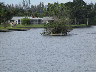
On our trip to Fort Myers, we saw what looked like a small island, but to me, it looked like it was under power. Looking through the binoculars, Clark confirmed it to be an island. Still I was not sure as it definitely appeared to be causing a wake.


An island with a wake???

I suggested Clark take another look, and he confirmed the island was "under way".


The island "under way" turned out to be a boat
carrying chopped down trees.

Otherwise, the trip into Fort Myers was uneventful. So uneventful in fact, it was downright boring. We had to travel through a long stretch of "Idle Speed - No Wake" for protected manatees that took forever to transit.

The entry to the anchorage was definitely a hair-raising experience. The channel is extremely narrow, and the water depth is shallow. With winds shoving us to and fro, Clark had his hands full keeping the boat in the marked channel. As he controlled the path of the boat, I called out depths to give advance warning should it start to look precarious. All I could see was one sailboat after another in the anchorage, and I had to wonder how the heck they got themselves into the anchorage. According to everything I read on Active Captain, the way we came in is the only way into this anchorage.


Fort Myers, FL - "between the bridges" anchorage


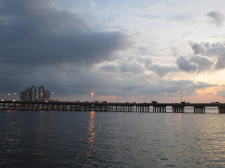
Sunset at Fort Myers, FL

Fort Myers, FL - evening sky


Fort Myers, FL at night


Tuesday 11/28/2017
Depart: Fort Myers Anchorage 9:30
Arrive: Kitty's Private Dock 10:30
Distance: 5 NM

This morning the winds had calmed down considerably, and the channel out of the anchorage did not present the same level of challenge as it did on the way in.


Skinny channel into / out of the "between-the-bridges" anchorage
in Fort Myers, Florida


We needed to travel the channel into the lagoons in Cape Coral where Kitty lives at high tide, so we hung out at the anchorage to pass some time before getting underway. Even though we arrived at the channel at the appropriate time, Clark traveled the channel at dead low speed to keep an eye on the depth and carefully search out the deepest water in the channel.

The lagoons are like a maze. Clark wove his way in but made a slight miscalculation on directions. We ended up getting to visit one extra lagoon on our way to finding Kitty's dock. When we finally arrived at Kitty's dock, she was waiting on the dock to help with our lines and electric. She is a wonderful harbor host!

View from Kitty's Dock in Cape Coral, Florida

After settling in and grabbing a quick bite for lunch, Kitty invited us to join her for a swim in her saltwater pool. We spent the rest of the afternoon with casual talk in her luxurious 87 degree pool.

Later, we joined forces and had a pot-luck dinner on Kitty's screened-in deck. She cooked on her grill, and I provided a pasta side dish. As a special treat, Kitty whipped up an amazing Key Lime Pie dessert complete with a banana split side including ice cream, fruit toppings and whipped cream.


Sunset in Cape Coral, Florida

Monday, November 27, 2017

W. P. Franklin Lock Park

Sunday 11/26/2017
Depart: Port Mayaca Dolphins 8:30
Arrive: W.P. Franklin Lock Park 5:00
Distance: 70 NM
Locks: Port Mayaca, Moore Haven, Ortana

Being tied up outside the lock made for a exceedingly short trip to enter the lock. Clark called the lock master to let him know we wanted to lock through. He told us to come ahead as soon as we had disconnected our lines from the dolphins.

Bow Line Tied to Dolphin at Port Mayaca

Port Mayaca Lock

After a reasonable-sized drop in the St. Lucie Lock, I anticipated something similar at the Port Mayaca Lock. I did all the normal prep work required to lock through

 * got gloves for handling the yicky lines and grabbed boat hooks to snab them
 * selected lines hanging from the lock walls that seemed reasonable length for a boat our size - some are longer than others
 * wrapped the lines around cleats to help hold the boat as the water adjusts level

I ended up changing lines twice to get the right angle of the line to the boat to provide the best holding capability. Finally, the lock master asked if we were all set for the drop. We said okay, and when done, the water had risen somewhere around 6" in height! I wondered if the lock master had a sense of humor and got a big kick out of folks preparing for a 6" change as if it would be several feet. After that, I decided to go refresh my memory of what to expect for the remainder of the Okeechobee Waterway.

Lock Lift to Lock
St. Lucie                  14'
Port Mayaca   6" to 2'
Lake 
Moore Haven
Okeechobee
1' to 2'
Ortona 7.5' to 8.5'
W.P. Franklin 2' to 3'

Given the ridiculously short ride in the lock, we exited the lock no more than 15 minutes after entering. Port Mayaca Lock is the last lock traveling westward before arriving at Lake Okeechobee. After the lake (heading west), the locks take us down instead of lifting us up.

We were fortunate today as the lake waters were relatively calm and we had a pleasant crossing. After traveling a canal, the lake offered lots of open water and some interesting sights.


Crossing Lake O (Okeechobee)


Uncharted Island on Lake O? Or is this floating?

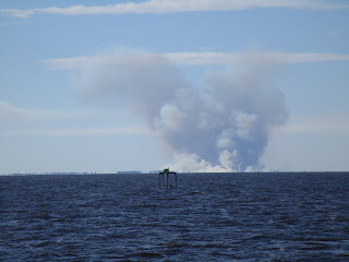
Smoke over Water - fires on the shore
(They do "prescribed burns" to burn off excessive weeds that choke the lake.)

We wove our way in a somewhat zig-zag pattern across the lake following the channel. For a few minutes I got busy reading email on my cell phone. When I looked up, I was absolutely shocked by what I saw surrounding the boat.

What happened to the open water? Are we entering a field?

Following the markers took us through the marshes towards Clewistown. We decided to bypass Clewistown on this trip; otherwise, we would have had to traverse the Clewistown lock to visit there.

Clewistown Lock coming into view

Park by Clewistown Lock
We had two choices for crossing to the west side of Lake Okeechobee - cross directly across the lake or take the "rim" route. After exiting the lake we made a right turn at Clewistown lock and intersected the rim route to continue on our way.

Because of the burns along the lake, the smell of smoke seemed to follow us on our travels. After Clewistown the acrid smoke made my eyes burn. Rounding a bend in the waterway, I saw why.

Heavy smoke made my eyes burn

cough - cough
After passing through this section, Clark found bits of burned, black grass on the boat. Traveling the open lake, we traveled 39 statute miles instead of the 50 we would have traveled had we followed the rim route. Perhaps we avoided a good portion of the smoke and fallout by avoiding the rim route.

The next lock after the lake was the Moore Haven Lock.

Park at Moore Haven Lock
 After exiting the lock, we had a skinny railroad bridge opening to pass through.  We came face-to-face with a sports-fish boat. Once again, we had the current with us and limited maneuverability. Clark called the captain of the fishing boat on the VHF radio, and before Clark could say anything, the other captain said, "I coming ahead." Clark said, "I have the current with me.", and he replied, "I have to make that lock before they close."


Rude boater at railroad bridge opening
made us fight the current while we waited for him to pass.


Moore Haven City Hall

Clark grabbed the camera for some photo opportunities as we traveled the waterway.

Building with what Clark called
 "the ugliest windows I have ever seen"

Cows on shore
(I pictured the one lifting his leg saying, "What did I just step in?!")
Trees reflected on the Okeechobee Waterway

After traveling all day and about 70 nautical miles, we finally arrived at the W.P. Franklin lock and park at 4:40. The locks stop operating at 5:00. Clark saw on Active Captain that we had a number of opportunities for places to stay for little to no cost on the east side of this lock. We could tie up to the dolphins again, or several dock options presented themselves including staying at a hotel dock or docks provided by the Army Core of Engineers at the lock park.

Clark had called ahead to the lock park to request accommodations for the night. The person he talked to said space was available, but she had no idea if our boat would fit. When I heard Clark tell her that "the bow is the pointy end and the stern is where the work happens", I knew she was clueless about boats. We had time to either try to make the lock before they stopped operating, or we scope out the park to see if we fit - not both. Clark opted for checking out the park.

Docking bow in, we fit, but just barely. Our bow was in the lily pads and our stern hung out beyond the end of the dock by several feet. When we checked in, we got a very pleasant surprise. The normal overnight stay for a boat of any size is $30 and includes free electric. Because we had National Park passes, we paid half price for the night!


Docked in the lily pads

After docking, we decided to walk around the lock park before / as the sun went down.


Sunset at W.P. Franklin Lock Park

"Shaggy" Tree at Sunset

To me, this looks like a heart-shape frame around the sunset.


Amazing cloud colors

Lock Park includes RV Park as well as slips for boats

Dam Water swirling

Dam Gates


Port Mayaca Lock -- Dolphin Tie Up

Depart: Fort Pierce, FL 9:45 / 10:20
Arrive: Port Mayaca Lock 6:00
Distance: 54 NM
Locks: St. Lucie Lock  ~20 foot drop


Early morning fishing at Ft. Pierce Marina


Boats, boats, and more boats at Ft. Pierce City Marina

As planned, we visited the Farmers Market before leaving Fort Pierce. I did not need much in the way of vegetables although they had a nice supply, but I did find a vendor with scones so I purchased several of them! Nancy from California lady stopped by and we went together. I asked Clark to come along as the photographer and the package carrier.


Fort Pierce Farmer's Market


2 Sections - Lots of Stalls (food vs. other goods)

Live Music

Handmade Crafts

Mike and Nancy - California Lady

After Nancy and Mike saw us off at the dock, we stopped at the fuel dock for a pump out. As we pulled up to the dock, Clark used the bow thruster which failed. We docked without it, completed our pump out, and prepped to leave the dock. When Clark went to start the starboard engine, it would not start. Apparently our starter battery and one other may also need replacement. Clark managed to start the engines by using the generator.

With it being a Saturday in Florida, we saw a lot more boat traffic than we've been seeing on other days. Most of this traffic was the run about kind. However we did see one interesting vessel - a tug pushing a barge carrying a tug.


Capt Bud (on barge) and Mr. Mike (tow)

I thought one of the speed boats zipping around had an interesting name - Aquaholic.

Sometimes the small craft can be quite annoying. We needed to have the Olde Roosevelt Bridge opened for us. The current was with us and there was no room for more than one vehicle to pass through the bridge at a time, but the small craft kept coming and blocking our passage. We had no chance to progress without running one over. The bridge tender was becoming impatient and called to us to tell us that we should proceed. Clark told him small craft were in the way, and he reminded Clark, as if Clark didn't know, that he had the right of way. I guess we were supposed to plow them under.


Small craft in the way of getting to the bridge opening!

On our trip along the Okeechobee Waterway today, we saw Riverland, went under the I-95 Bridge, and under Florida's Highway.

Riverland, Florida
I-95 Bridge over the Okeechobee Waterway


Because of our late start with the farmer's market and pump out, we started to worry as the day progressed about making our anchorage destination for the night before the sun set. Our timing was poor by about 15 minutes arriving at the St Lucie lock. We had a 30 minute wait before the lock opened and then a 30 minute ride up in the lock. This hour of time spent locking definitely made us worry about our trip.


24 Statute Miles to go to get to the Port Mayaca Lock

When we exited the lock, we passed a trawler with a Gold Looper flag on a boat named Ivanhoe. As we passed each other, we pointed each other's gold Looper flags and waved like crazy. We're always very excited to see other Loopers even those we don't know. Perhaps one day we'll meet the folks on Ivanhoe.

We hoped for clear sailing after we left the lock until we reached our destination for the night, but that was not to be the case. We arrived at the Indiantown railroad bridge surprised to find it closed. Unless the train is coming the bridge is normally open. When Clark called the bridge tender, he told us that a bridge was on its way in about 15 minutes.


Looking into the sun glare waiting for the railroad bridge to open

After waiting what felt like forever, we were dismayed to see that the train was a freight train with three engines. This was very bad news. As I did when I was a child in a car waiting at a railroad crossing, I started counting cars. I counted somewhere around 125. We thought we'd never see the last of it.


Finally! Looking back at the open RR bridge!


Given the late hour and the distance left to travel, Clark decided we should try to get a slip for the night at the Indiantown Marina. He tried calling the office, calling the service desk, and calling via the VHF radio. Late afternoon and no one was home! We kept going.

To make up lost time Clark decided to push the throttles up for a while. This serve two purposes: 1 get us there faster and 2 blow some of the carbon out of the engines. At 2800 RPM we got up on plane and were moving. Of course the major drawback to this mode of operation is fuel consumption. We went from 8 Kts. @ 4.5 gallons per hour to 15 kts. @ 26 gallons per hour.

We did make it to our planned destination at just about sunset. Clark had called ahead to the Port Mayaca lock to request permission to tie up between two dolphins. (The definition of dolphin in this case is a piling used for mooring a boat.) Along the way we captured some end-of-day photos.


Trees reflected in our wake.

Sun setting and we still have miles to go.

"Guillotine-style" railroad bridge - thankfully with no train!

Dusk - tied to dolphins bow and stern for the night!